La Basse Cour: B&B near Alencon, Normandy
Normandy B&B : Perseigne Forest
The Perseigne Forest, belvedere and villages

Perseigne Forest, Normandy-Pays de Loire
This driving tour (also possible by bicycle for strong cyclists) takes you through the Perseigne Forest and some of the villages which grew up around it. The Perseigne covers 5000 hectares (about 12,500 acres) and is part of an ancient forest that once covered all of the Perche region. Its hilltop setting makes the forest a major landmark for miles around and it is a magnet to walkers, riders and mountain bikers. However, due to its immense area you can go for miles and not meet another soul.


Perseigne Forest, Normandy-Pays de Loire
Due to its relief, the Perseigne has some of the best natural MTB trails / VTT pistes in France.
Begin by leaving Ancinnes on the Route Forestière d'Ancinnes, which climbs up into the forest from the junction after the shops.
You are soon in the forest and you will pass on your right, at a kink in the road, a giant sequoia tree. This magnificent tree can be seen poking up above the forest canopy for miles around; it is over 100 years old and was 35 metres in height when measured in 2000. Shortly after this landmark you come to a crossroads where the Route Forestière de Livet crosses the Ancinnes forest road.
The GR22 and the GR22c footpaths run through the forest - the Route Forestière d'Ancinnes is actually part of the GR22; this is a Pilgrimage route leading to Le Mont St Michel, while the GR22c is a side route which passes directly through Ancinnes. The forest is creased by deep valleys such as Holly Valley (accessible only on foot), Hell Valley and the Layée Valley, formed by the many streams which have their source here in the Perseigne.
The forest is rich in wildlife, supporting 70-odd species of birds plus red and roe deer, wild boar, hares, foxes, red squirrels and martens. The main tree species are oak, beech and pine and in spring and autumn the undergrowth is thick with mushrooms - ceps, bolets, chanterelles, morilles and more.
Dotted thoughout the forest by the side of the road there are picnic tables for lunch. Many are rather well concealed so you have to have your eyes peeled! If you walk into the forest make sure you keep to the main paths or you can easily get lost. If you want to explore more deeply we can loan you a detailed map of the forest - the woodland is divided into numbered 'parcelles' and some trees bear numbers indicating the limit of each parcelle, a useful aid to navigation off the main paths.
If you're on foot or bike, at the crossroads of the Route Forestière de Livet you can continue straight on the Route Forestière d'Ancinnes to the D311, then cross straight over and you shortly come to the Croix Samson crossroad. Carry straight on at the Croix Samson crossroad; at the next crossroad, the Croix de Pergeline, bear left. As the road descends, you pass a large sequoia on your left; shortly after, turn left and descend the hill to the D236 and at the bottom turn right to les Ventes-du-Four. If you're driving then you have to turn left at the Route Forestière de Livet, descend a steep hill and turn right at the bottom and continue going straight on, crossing the D311 to arrive at les Ventes-du-Four. As you enter the village there is a curious little chapel on your right; this houses a small statue of the Virgin, Notre Dame du Chêne, who legend has it appeared here to a woodcutter in a vision.
Continue on the D17 to la Fresnaye-sur-Chédouet. Here there is a museum dedicated to cycle racing, with a display of bikes from the early 1800's to the present, videos and interactive displays evoking the excitement of the Tour deFrance and other classic races. Open April to September, Wednesday to Sunday from 10h to 13h and 14h to 18h.
Return to les Ventes-du-Four; as you enter the village turn left on the D234 then left again on the Route Forestière de la Fresnay-sur-Chedouet in the direction of Louzes. This road marks the northeastern boundary of the forest, which rises up on your right. Near Louzes bear right, then at the crossroad marked by a picnic site at the foot of the hill turn right again, climbing up once more into the forest. You pass an ancient quarry on your right, stone being the second natural resource for which the forest was exploited. At the crossroads at the top of the Col des Quatre Gardes turn right then immediately left to the Belvedere de Perseigne, a tower and viewing platform which is perched on the highest point of the forest. Open 1pm to 6pm weekends only in April, May, June and September, 11am to 7pm Wed-Sun in July and August. On a clear day the view from the top (163 steps, 35 metres) is stunning - you may even make out the spires of the cathedral in Le Mans. Not to be missed, don't forget to take some binoculars. There is a "parcours santé" for exercise next to the belvedere and a series of panels illustrating the flora and fauna of the forest.
Just after the belvedere turn left into Hell Valley (Vallée d'Enfer). Contrary to its name, the valley is delightful as the road follows a stream down to the Carrefour des 3 Ponts. Here you will find a picnic area and a number of paths going off in various directions. Try walking up the Holly Valley (route du Gros Houx) if you prefer it firm underfoot, or strike out along one of the many other forest paths if you're feeling more adventurous. This is where a map of the forest is useful!
Afterwards drive on in the direction of Neufchatel but turn left after about 600m towards the ruins of the Abbey of Perseigne. Not much remains of this once important abbey, built by the same Cistercian monks responsible for the church at St Rigomer. The best view is on your left from the road as you go up the hill. The abbey is on land owned by a conference/recreation centre now and while still accessible to the public, visitors wishing to get closer should restrict themselves to the field where the ruins lie. The most famous inhabitant of the Abbey was Adam of Perseigne. He was born about the middle of the 12th century and is thought to have been first a canon regular, later a Benedictine of Marmoutier and finally a Cistercian monk. About the year 1180 he became Abbot of Perseigne, where his reputation for holiness and wisdom drew the great and good of his time to seek his counsel. He met with Joachim, the celebrated mystic and Abbot of Flora in Calabria, Italy, whom he advised on the subject of the latter's revelations. He also aided Foulques de Neuilly in preaching the Fourth Crusade. His letters and sermons were published at Rome in 1662 under the snappy title 'Adami Abbatis Perseniae Ordinis Cisterciensis Mariale'. The abbey was sacked following the Revolution and its goods sold off at public auction.
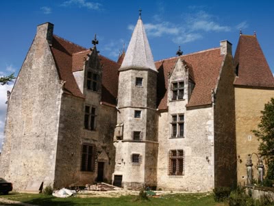
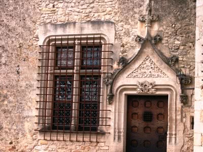
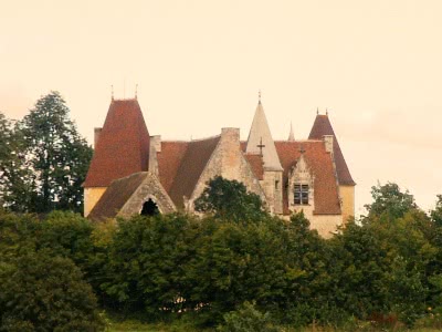
At the top of the hill turn left and head towards Aillières-Beauvoir. After about 3km near a picnic site turn left up the pretty Route Forestière de la Vallée Layée. At the top turn right on the D234 to Aillières-Beauvoir. In this little village there is a nice restaurant, the Orée du Bois. Just after the restaurant turn right into the car park for the church of St Denis, built between the XI-XIV centuries. Next to the church is the Chateau d'Allières. Part of the defensive line built by Robert II of France in the twelfth century, it has been owned by the lords of Allieres since the fourteenth century. The original fortress was destroyed by the English in the 100 Years War but the chateau was rebuilt in its present form in the XVIIth century. There are panoramic views from the gardens and terraces, which are open to the public in the afternoon from 1st July to mid-August.
Return past the restaurant and turn left towards Villaines-la-Carelle and there take the D202 to Vezot. At Vezot there is an XI century church - if you would like to view the interior, park by the church and ask for the key at La Cour, the ancient fortified farm next to the car park. Turn back from the church and take the road to St Rémy-du-Val. This pretty little village has a country life museum run by a lovely old couple which is well worth a visit (open Sundays in summer) and a XII century church perched on a rocky promontory. Park in the centre near the bar and walk past the church, taking the path up to the ruined castle. From here there are wonderful views over the surrounding countryside.
Take the little road right and downhill out of the village signposted Ancinnes but just after the stud farm (on your left) turn left and rejoin the road to Louvigny. You soon arrive at the Logis de Moullins on the road from St Rémy-du-Val to Louvigny - this is open to the public Mon-Fri for two weeks in each of July, August and September and by appointment at other times. The architecture testifies to many centuries of development (Gallo-Roman, 13th, 14th and 15th centuries): the surviving buildings include the remains of a priory founded in 995 and destroyed by the army of Henry V of England in the 15th century, the abbatial structure from the early 16th century, the chapel dedicated to Saint Catherine and a dove cove from the same period, all built on the site of an immense Gallo-Roman domain. During the Revolution the buildings, and particularly the chapel, were severely damaged and their materials re-used for other purposes. The property was purchased in 1982 by its current owners and loving restoration is still in progress.
Continue to Louvigny and take the D19 to Ancinnes. On the descent towards Ancinnes there are some lovely views of the village through the woods on your left; on the approach to the village you will pass the fishing lake, picnic area and children's playground.
Alternatively, you can take the D271 from Louvigny to Bourg le Roi before returning to Ancinnes. This ancient walled 'cité' still shows remnants of its proud past, with a ruined keep, well preserved ramparts and massive granite portals to the east (as you head towards Ancinnes) and south (from Louvigny). There is a small embroidery/tapestry museum which you must visit if it is open when you are there; there are regular demonstrations during summer weekends. There is a well-preserved "lavoir", or washhouse, in the gardens which lead from the church to a small lake. The tiny butcher's shop also sells wonderful rillettes and boudin made on the premises and there is a bar (which shuts for lunch!). In the centre of the square is a memorial marking the point where General Leclerc rested during the liberation drive north to Alençon.
Return on the road through the eastern gateway to Ancinnes.