La Basse Cour: B&B near Alencon, Normandy
Walking in Lower Normandy and Alpes Mancelles
Cycle Routes in Lower Normandy and Alpes Mancelles
Walking and Cycling in Lower Normandy and Alpes Mancelles

Walking and Cycling Circuits
The Forest of Perseigne is 5 minutes from our door on foot. There you can walk or ride for miles without meeting another soul. Either by bike or on foot, you will delight in exploring the forest pathways, quiet roads and wonderful countryside.We are also close to the GR22, a "Grand Randonnée" hiking route, which runs from Paris to Le Mont St Michel and passes through the Forest of Perseigne.
A side route of the GR22, the GR22c, runs through Ancinnes from Neufchatel en Saosnois to the Alpes Mancelles and links with several other walking routes.
Bike Hire
Road bikes and mountain bikes can be hired from Bayi cycles in Alençon or nearer to us you can hire mountain bikes from the Maison des Randonnées at Neufchatel-en-Saosnois.
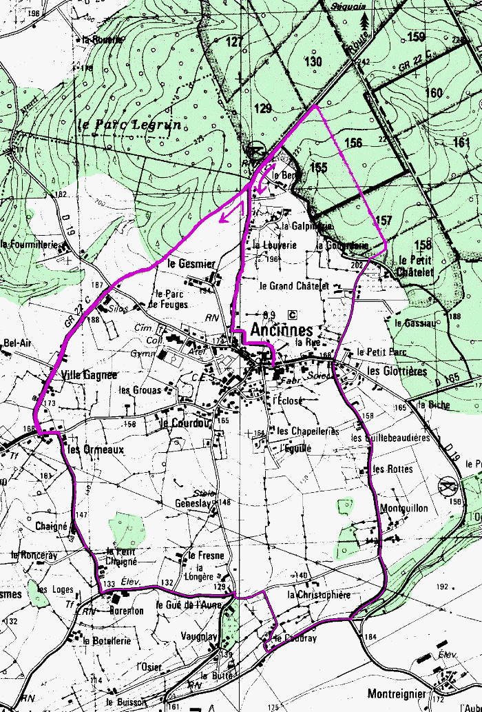
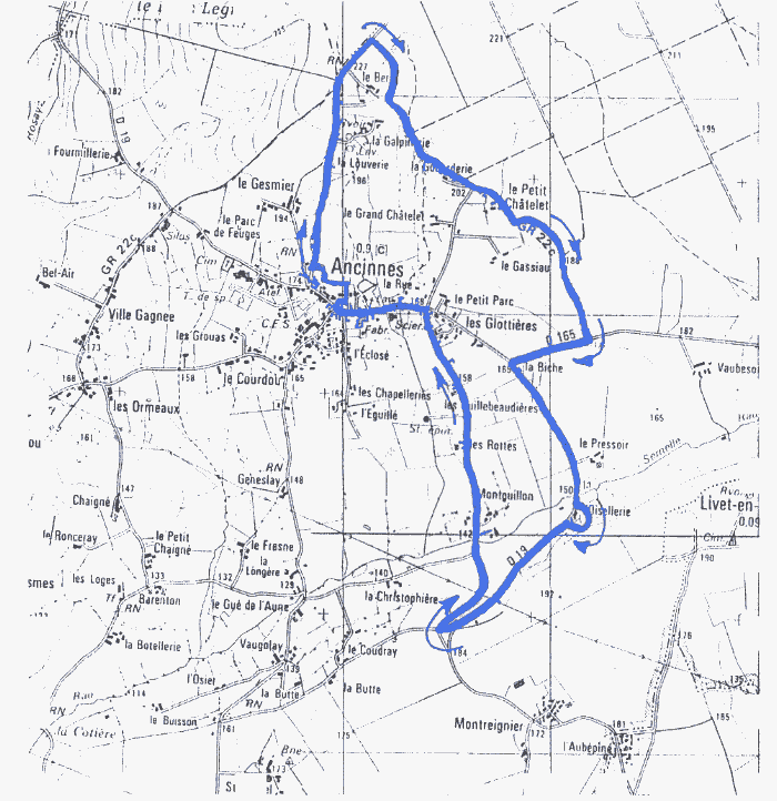
1. Ancinnes and its environs
Print/download (255k pdf) with Acrobat Reader
14km (9mi)
DEPART: ANCINNES
- From the Mairie take the road alongside the meadow and at the end turn right up the Route forestière d'Ancinnes
- Keep going up past "la Louverie" and "le Berry"
- Before the picnic area, turn left on the bridlepath along the side of the forest. Views of the village on your left, the Perseigne forest on your right.
- Cross the D19 in the direction of "Bourg le Roi"
- At "les Ormeaux" turn left then right in the direction of "Barenton". Pass the château farm "Chaigné ".
- After le Petit Chaigné, turn left. Pass "Barenton".
- At "Le Gué de l'Aune" turn right and immediately left - cross the stream "la Semelle".
- After 200m take the little road that goes uphill to "le Coudray". Turn left on the road known as "la passe-vite", where a French tank was destroyed by Germans defending Ancinnes on the day of its liberation 11 August 1944. Beautiful views over the valley and village to your left.
- Just before a triangle of land where a windmill once stood, take the steep, narrow road downhill towards Ancinnes. Pass "Montguillon", "les Rottes", "les Guillebeaudières".
- When you reach D19, cross it and head uphill to "Le Grand Châtelet" and "Le Petit Châtelet".
- Go straight ahead into the Forêt de Perseigne and turn immediately left onto a footpath which takes you in a straight line to the Ancinnes forest road.
- Turn left at the end to return to the village.
Top
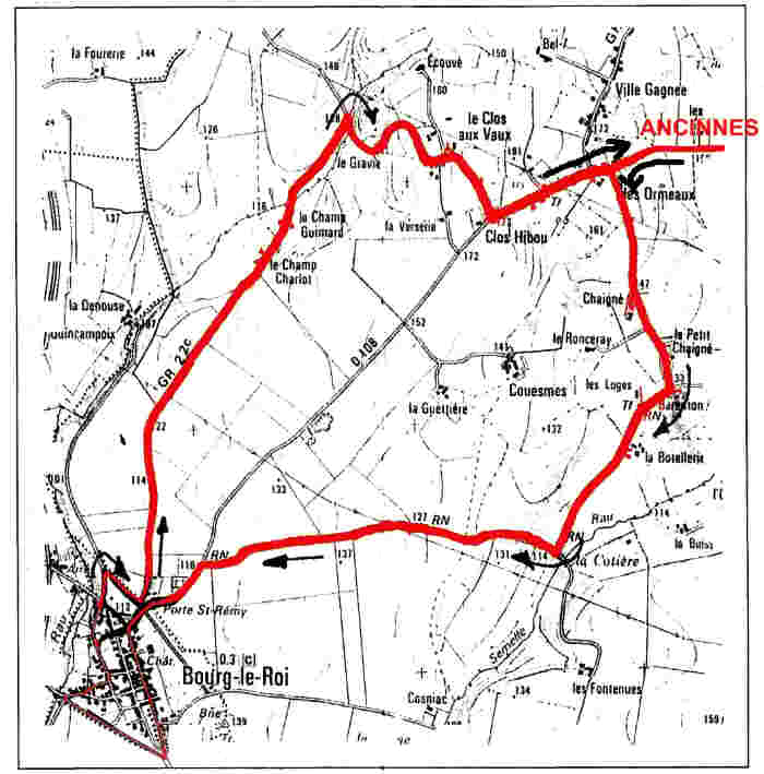
2. Ancinnes to Bourg le Roi
Print/download (205k pdf) with Acrobat Reader
11km (7mi)
DEPART: ANCINNES
- From the church take the road to Bourg le Roi
- At "Les Ormeaux", turn left to "Chaigné" and "Barenton"
- At "Barenton", turn right and pass "la Botellerie"
- Then turn right again and arrive at the D108 - go left
- Pass the cemetery and arrive at BOURG-LE-ROI by the Saint-Remy Gate
- Take the rue de la Libération to the left and pass the ruins of the château (on top of the hill on the left)
- Leave by the St Mathurin Gate next to the chapel and take the rue des Ramparts to the right
- Re-enter the village by the rue des Plantagenets; turn left to the church
- Go around the church (notice the "lavoir" in the garden down the slope) and come around to place du General Leclerc - memorial to the French WW2 general who paused there during the Battle of Normandy
- In the square turn left in the direction of CHERISAY, then turn right at a barn outside the ramparts
- Walk up the track to the Saint-Remy Gate, then turn left down the GR22c
- Pass the farms "le Champ Chariot" and "le Champ Guimard" and cross a bridge
- At the intersection, fork right in the direction of "le Gravier"
- Continue uphill as far as "Clos Hibou", then turn left on the D108
- Continue to Ancinnes
Top
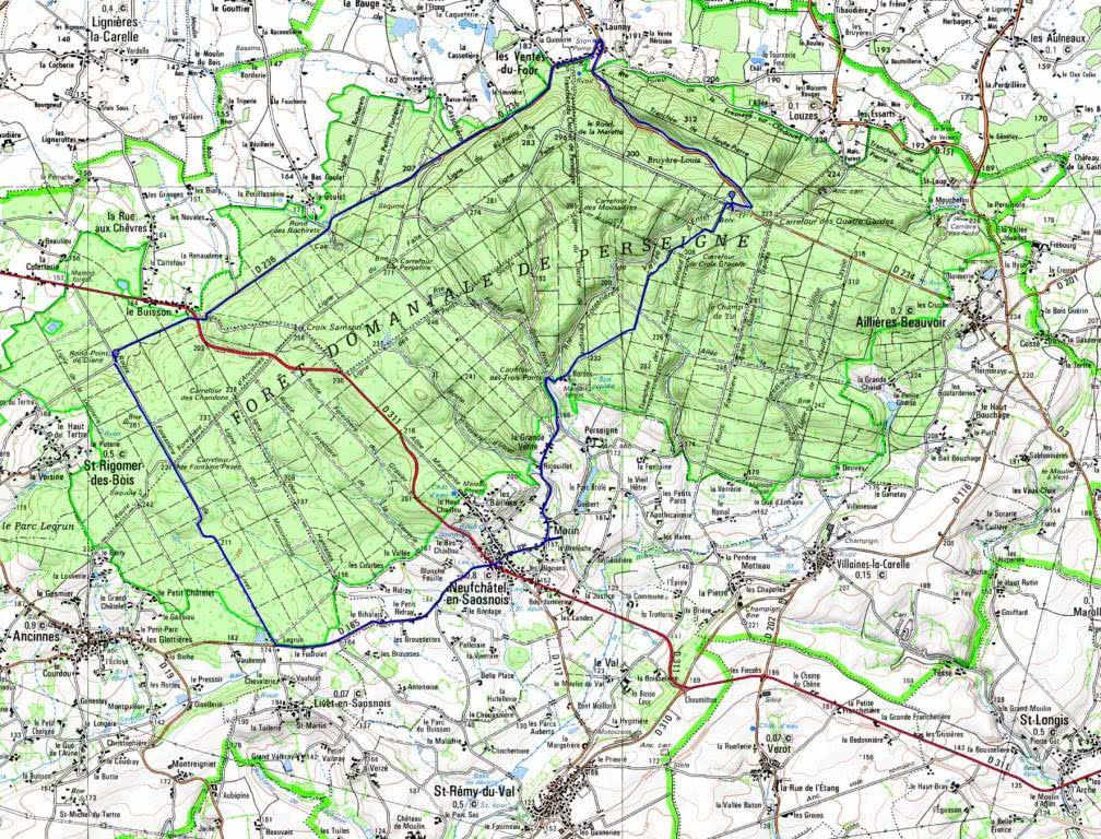
3. Perseigne Forest, Belvedère, Vallé d'Enfer 30km
Print this bike circuit map
ANCINNES - PERSEIGNE FOREST WALKS AND MOUNTAIN BIKE ROUTES
WE HAVE DETAILED MAPS AVAILABLE FOR GUESTS AND THERE ARE SEVERAL SIGNPOSTED CIRCUITS.
The forest can be explored on foot or by mountain bike and is criss-crossed by forest roads allowing easy vehicular access to the interior.
Off the forest roads, the forest paths are unpaved - walking boots are strongly recommended, particularly in wet conditions as streams cross the paths in places. Nearby the forest is relatively flat for the most part, but you do not have to venture far to find plenty of vigorous routes such as those along Hell Valley (Vallée d'Enfer) and Holly Valley (Grand Houx) near the Belvedere de Perseigne, the viewing tower located at highest point in the forest.
THE PERSEIGNE FOREST COVERS 6000 HECTARES (15000 ACRES).
Top
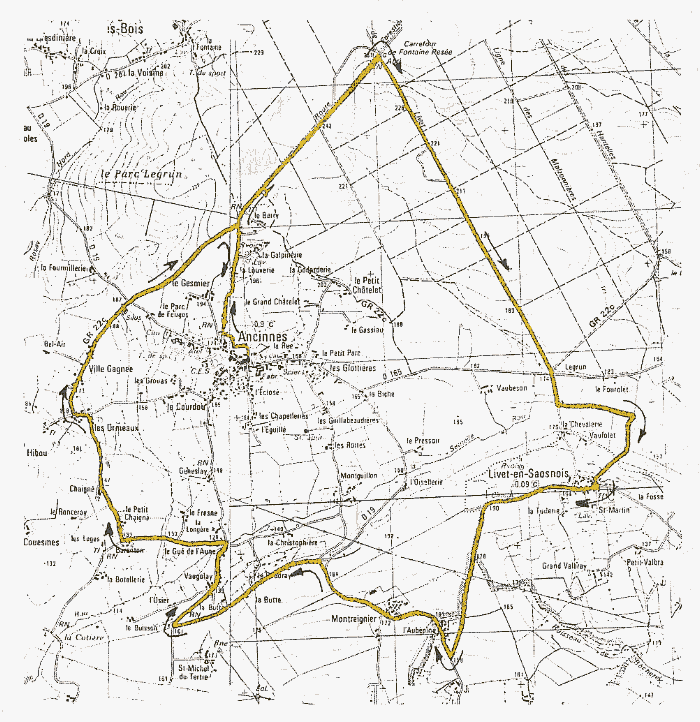
4. Ancinnes, Perseigne, Livet, Montreignier, Les Ormeaux
Print/download (249k pdf) with Acrobat Reader
17km (11mi), yellow signposts
DEPART : Ancinnes near the church - follow yellow signs
- From the Mairie take the road alongside the meadow and at the end turn right up the Route forestière d'Ancinnes
- Keep going up past "la Louverie" and "le Berry"
- Take the earth track straight on at the bend with the Giant Sequoia and come to the crossroads of "Fontaine Pesée"
- Take the track to the right "ligne forestière de Livet" which leads to the étang de "Vaubezon"
- Cross the D165 and continue a few hundred metres on the C7, then take the half-tarmac dead-end road to the left (voie sans issue); then turn right up to the village of LIVET
- Arriving at the church (see the lavoir de Saint-Martin, down road past Mairie) head for LOUVIGNY, passing the cemetery outside Livet.
- Arriving at the main road D19, turn right and go past "l'Aubepine" and "Montregnier"
- At the junction turn left then left again passing "le Coudray" et "la Butte". After la Butte, turn sharp right and pass "Vaugolay", "Au Gué de l'Aune". There, turn left to "Barenton"
- Turn right there and pass "Petit Chaigne" as far as "les Ormeaux". Take the D108 off to the left and shortly turn right to "Ville Gagnée"
- Joining the GR22c, cross the D19 et take the bridlepath up to the forest. You will come to the Route forestière d'Ancinnes. Turn right downhill and come back to the village.
Top
5. Ancinnes to the étang de l'Oisellerie
Print this page (177k pdf) with Acrobat Reader
7km (5mi), blue signposts
DEPART : Ancinnes near the church - follow blue signs
- From the Mairie take the road alongside the meadow and at the end turn right up the Route forestière d'Ancinnes
- Keep going up past "la Louverie" and "le Berry"
- Just after le "Berry", take the GR22c bridleway off to the right into the forest
- Emerging from the forest, pass "la Godarderie" and "le Petit Chatelet" on your right, keeping the forest on your left
- Re-enter the forest just after le Petit Chatelet and eventually you come to the D165;turn right and follow it to the T junction and turn left along the D19
- Arrive at the fishing lake "l'Oisellerie", take a tour around it and come back to the D19; head uphill
- At the top turn right and right again - before heading downhill have a look at the view over Ancinnes. Descending, pass "Montguillon", "les Rottes", "les Guillebeaudières"
- Arrive back at Ancinnes
Top
6. Foret de Perseigne mountain bike circuit No.7 22km
Top
7. Foret de Perseigne mountain bike circuits No.7 and 10 37km
Top
B & B Normandy